Contents
So you’re looking for a Guanacaste Costa Rica map—smart move. Before you start bouncing from beach to beach like a sun-chasing ping-pong ball, it helps to know where things actually are. Guanacaste looks compact on paper, but trust me: one wrong turn on a dusty road and suddenly you’re 45 minutes into a cattle ranch wondering where the ocean went.
This isn’t just about geography—it’s about understanding the vibe of each spot. Guanacaste is dry, golden, and full of everything from surf towns and sleepy fishing villages to luxury resorts and dirt-road yoga outposts. Having a map is great. Knowing what to do with it? Even better.
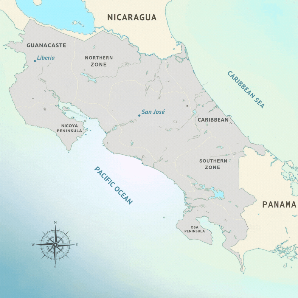
Map of Guanacaste – Where Even Is Guanacaste?
Let’s zoom out for a sec. Guanacaste is the northwestern province of Costa Rica, bordered by Nicaragua to the north and the Pacific Ocean to the west. It’s dry season central—known for its sunny weather, open landscapes, cattle country, and endless coastline. You’ll fly into Liberia International Airport (LIR), not San José, which already puts you close to the action.
A map of Guanacaste Costa Rica will show you towns scattered along the Nicoya Peninsula and inland through dusty hills and volcanoes. You’ve got paved roads, gravel roads, roads that used to be roads, and a few river crossings that your rental agency definitely didn’t mention.
Beach Towns In Guanacaste That Should Be on Your Map
Once you look at the map, a few names will jump out—and each one has a totally different flavor.
Tamarindo
The unofficial capital of beach vibes. Surf, bars, good food, and easy access. Great for first-timers, digital nomads, and people who want a bit of everything (with Wi-Fi).
Playa Flamingo
A touch fancier, with a marina and some upscale resorts. Sunsets here are next level.
Playa Conchal
White-shell beach, turquoise water. You might think you’re in the Caribbean. Perfect for swimming and relaxing.
Playa Avellanas & Playa Negra
Surf-town cool with fewer crowds. Sand, surf, and smoothies. Bring your chill.
Nosara
Yoga, organic everything, dirt roads, and expat families wearing linen. If you’re looking for zen, it’s here.
Sámara
Laid-back and walkable. Great for families and people who want to sip cocktails and still hear howler monkeys in the background.
Plot those on your Guanacaste map, and suddenly your itinerary starts making a lot more sense.
What the Guanacaste Map Won’t Tell You
Distances look short—but this is Costa Rica. “25 km” could be 30 minutes… or 90. Some roads are paved. Some are pothole obstacle courses. And if it rains? Well, that charming river shortcut becomes a swimming pool.
Plan your route based on vibe, not just convenience. For example, Tamarindo and Conchal are close and easy to combine. Nosara to Santa Teresa? Looks doable. Feels like an odyssey.
Also, be ready for detours. A cow in the road. A spontaneous beach stop. A fruit stand that sells the best pineapple you’ve ever tasted. That’s part of the magic.
Want to Skip the Navigation Stress?
We get it. Not everyone wants to plan their route based on how many chickens are crossing the road. That’s why we make it super easy to book tours, guides, and experiences without needing to figure out which beach town has the sloths and which one just has surf bros.
At GoExploreWith.me, you can browse and book amazing Costa Rica adventures directly—without guesswork. Just choose what excites you, and we’ll handle the rest. Because let’s be honest: it’s way more fun to explore than to argue with GPS.
Want More Than Just the Tourist Trail?
We’ve put together a free eBook called “10 Hidden Gems in Costa Rica You’ve Never Heard Of.”
It’s full of places that probably aren’t even on your map yet—quiet beaches, jungle towns, and small adventures that feel like your own secret. Download it now, and add a few dots to that Guanacaste Costa Rica map that no one else has.